
MELISSA MAKES LANDFALL: HISTORY, HAVOC, AND A PERFECT MONSTER
- Rich Washburn

- Oct 28, 2025
- 4 min read


At 1:01 p.m. Eastern, the storm everyone feared finally crossed the line. Hurricane Melissa — the once-theoretical “worst-case” storm for Jamaica — made landfall near New Hope, St. Elizabeth Parish, with maximum sustained winds of 185 mph and a central pressure of 892 millibars.
That ties it with the 1935 Labor Day Hurricane and Hurricane Dorian (2019) as the strongest landfall ever recorded in the Atlantic Basin. One hundred years later, nature just broke its own record — again.
Melissa didn’t blink. It didn’t weaken at the coast. It came ashore perfect. And that’s what makes this one different.
The Cat-5 Reality Check
If you’ve never seen what 185 mph wind does, don’t think “trees swaying.” Think asphalt peeling, steel bending, and buildings losing arguments with physics.
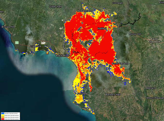
In western Jamaica — Black River, Treasure Beach, and Negril — the ocean has turned vertical. Surge models from NOAA’s SLOSH system show six feet or more of saltwater above normally dry ground, and the radar imagery looks like a living fireball.
The eye itself — that eerie calm — is a dry, warm void, almost hot. Meteorologists say Melissa’s eye temperatures rival a Jamaican summer day, the kind of atmospheric compression that marks only the most intense cyclones on record.
This is not “the storm of the year.”This is the storm of the century.
Eyewall Without Replacement: A Meteorological Oddity

A hurricane this powerful usually burns itself out before landfall — that’s called an Eyewall Replacement Cycle (ERC). Melissa skipped it.
That means it hit the island still in its maximum spin state — like an engine running full throttle without ever downshifting. Meteorologists will be studying this one for decades.
This was a storm that said: Why pause for maintenance when I can break records instead?
The Human Layer
By mid-afternoon, one-third of Jamaica was already without power. 50,000 people displaced. Shelters overflowing. Communication fading fast.
Treasure Beach and Black River are likely underwater; Montego Bay is being mauled by the back half of the eyewall. Flooding has reached the Alligator Pond area in Manchester Parish, and early video out of St. Elizabeth shows storm surge swallowing cars.
It’s going to take hours, maybe days, before we know the real cost.
But even now, this is already a humanitarian crisis — and one that will test the region’s response systems as it grinds toward eastern Cuba and the Bahamas.
For The Weather Geeks (And Those of Us Pretending Not to Be)
Let’s talk structure for a second. At 892 mb, Melissa’s pressure gradient — the difference between calm center and violent edge — creates what meteorologists call catastrophic isobar packing.
That means the air around the storm is collapsing inward faster than it can equalize. The winds you feel at the surface — the screaming 185s — are the atmospheric equivalent of a vacuum slamming shut.
And here’s the kicker: the Hurricane Hunters couldn’t even finish their last pass.They hit turbulence so violent that the Air Force aborted the mission.When the pros who fly into storms pull the plug, you know what kind of animal you’re dealing with.
“This Is Not A Joke”
Those were the words from Jamaican officials on live TV this morning — and they meant it. By 9 a.m., the government confirmed that only about 1,000 people had made it into official shelters. That’s barely a fraction of those in the surge zone.
At 10:18 a.m., the National Hurricane Center issued its bluntest possible statement:
“CATASTROPHIC WINDS MOVING ONSHORE SOUTHERN JAMAICA … LAST CHANCE TO PROTECT YOUR LIFE.”
And yet — even with those words echoing — videos poured in of people standing in flooded streets, phones up, filming the eyewall. Humans are curious. Storms don’t care.
What’s Next
Melissa will now rake the island for the next several hours before emerging over water again. From there, the forecast track brings it toward eastern Cuba and then the Bahamas, still likely a Category 4 or strong 3.
If you’re in those regions — you are not watching someone else’s tragedy. You are looking at your 48-hour warning.
International aid from Miami, London, and Kingston is already being mobilized, but infrastructure damage will delay everything. Roads are impassable. Airports are closed. Communication is spotty.
This is going to be a slow-motion disaster.
Why This One Stings
For meteorologists, this is fascination meets heartbreak.For Jamaicans, it’s survival and loss. And for the rest of us, it’s a glimpse of what a hotter ocean and a hungrier atmosphere can create when given free rein.
Oh — and for those keeping an eye on Jamaica’s most famous cash crop:yeah, marijuana futures just got smoked. Somewhere, a field in Negril is airborne right now.
Perspective
I’ll say it again: weather isn’t a sideshow. It’s the original system architecture — the first and last force we ever had to engineer around.
Melissa is what happens when that architecture flexes its full range. It’s fluid mechanics meeting climate volatility, and it doesn’t care about the timestamp on your push alert.
I’m sitting here in Florida, safe, dry, lights on — trying to imagine what it sounds like down there when 185 miles per hour meets a tin roof.And even as I geek out over the satellite loops, I feel it in my gut: the awe and the ache of it.
Because this storm isn’t just weather. It’s a warning written in wind.
#HurricaneMelissa, #JamaicaStrong, #Cat5Storm, #ExtremeWeather, #ClimateCrisis, #StormChaser, #WeatherUpdate, #CaribbeanResilience, #HurricaneSeason, #NatureUnleashed


Comments